|
|
|
|
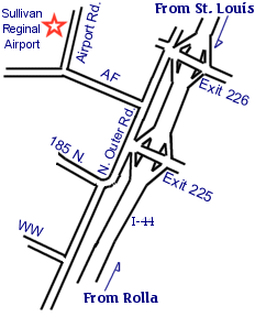 Click here for a larger map Click here for a aerial photo of the drop zone Sullivan Missouri Regional Airport, opened in 1991, features a 4,500' x 75' concrete runway with NDB/GPS approach and VASI approach lights, a full service FBO with JET A and 100 octane fuels at the pump. Only one mile from Interstate 44 (old Route 66). Just a couple of miles from the Meremac State Park and river recreation area. From the St. Louis metropolitan area take Interstate 44 West to the first Sullivan, Missouri exit #226, (Meramec State Park exit). Turn right at the top of the ramp, and then turn left on the service road (HWY 185 north). Go west approximately 1/2 of a mile to the Sullivan Regional Airport sign, and turn right on highway AF. Go north 3/4 of a mile to the Quantum Leap sign, and turn right on Airport road. It takes approximately one hour to drive from most parts of the St. Louis metropolitan area, a little less from the West County area. We are located 1/2 hour West of the Six Flags Amusement Park. From St. Charles County, take your best route to Interstate 44 and go West following the directions above. From Jefferson City, Missouri take Hwy 50 East to Hwy 63 South to Hwy 68 South to St. James, Missouri. Then take Interstate 44 East to the 1st Sullivan exit #225. Turn left at the top of the ramp, cross over the Interstate and turn right on the north service road (HWY 185 south). Go east approximately 3/4 of a mile to the Sullivan Regional Airport sign, and turn left on HWY AF. Go North approximately 3/4 of a mile to the Quantum Leap sign, and turn right on Airport road. It takes approximately 1 1/2 hours to drive here from Jefferson City. Recreation nearby - Meramec State Park and Meramec River Recreation Area featuring:
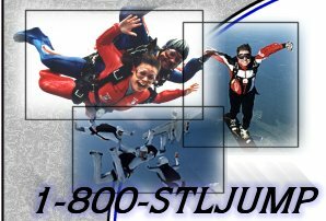
Home | Shopping | History | Programs | Equipment | Calendar | Multimedia Location | Reservations | Links | Guestbook | Contact Us |